FLA-SHOP.com - Interactive Maps with Greater Impact!
Multi-level Map of Africa 1.3
Complete set includes
|
Features
- ease to use for everyone
- small file size, low overhead (webtraffic)
- innovative & unique Flash Map Interface
- URL & PHP & Mysql linking
- self selection of colors, look & feel, captions and more - all 100% customizable!
- customization via XML; no flash modifications required
Any setting can be achieved using an external XML file; this allows integration of a flash map into any application with easy and dynamic modification of map information - customization popup-windows and tooltip
- compatible with all scripting languages like ASP, PHP, ColdFusion, Perl, etc.
Use any programming language to create an XML source file and transfer it to your Flash object, or simply use an XML file from your server
Configuration and customization via xml
All adjustments and customizations are made in XML files. It can be opened with an standard text editor, like Windows Notepad, Notepad++ or Macromedia Dreamveawer. Certainly, you can use any other web editors which are available at the market. The configurations and customizations are made on your local computer, after configuration and customization you must upload only the edited files to your webserver directory. Thats it!
config.xml
| name_color="ffffff" | Color of name of state |
| name_shadow_color="000000" | Color of shadow of a name |
| name_font_size = "11" | Font size |
| background_color = "ffffff" | Color of a background |
| borders_color = "ffffff" | Color of a borders |
| popup_background_color = "ffffff" | Color of a background of popup box |
| popup_borders_color = "999999" | Color of a borders of popup box |
| popup_text_color = "000000" | Color of a text in popup box |
| sounds = "on" | On/off sounds |
| animated_state = "on" | On/off animated rollover effect |
| gradient = "on" | On/off gradient rollover effect |
| path = "map/data/" | Path to SWF and XML files |
| path_to_images = "map/" | Path to images files for popup |
For each country/state it is possible to define the name, color, rollover color, link(URL), description (if it is necessary), image and the target frame.
For country/state at the first and second level probably to specify parametres for a map of the third level.
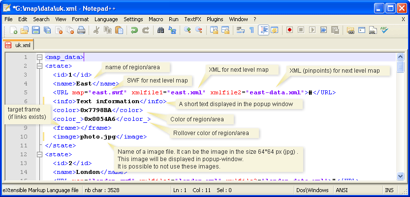
| <state> | |
| <id>1</id> | The ID of country/state |
| <name>Alabama</name> | Name of country/state |
| <URL>#</URL> | For parameter URL it is possible to appoint the following:
URL = "yourfile.html" - link for file URL = "#" - means the map of this country/states opens URL = "" - there is no data - country/state inactive. |
| <popup>text</popup> | The text for a pop-up window at rollover the mouse on state. To break line press "Enter", or use a code || or code <BR> |
| <color>0x7798BA</color> | Color of state. RGB-hex code. 0xffffff - white, 0x000000 - black |
| <color_>0x366CA3</color_> | State rollover color |
| <frame></frame> | Target frame |
| <image>photo.jpg</image> | Name of a image file. It can be the image in the size 64*64 px (jpg). This image will be displayed in popup-window. |
| </state> | |
| ... | ... |
Define coordinates of Your objects
Opportunities:Editing XML of files for state level
Use double click on the country for opening of a map of a following level.Addition of a point
1. Enter the name of a new point.
2. Click on a map in any place.
Editing
1. Click on a point.
2. Edit the information.
3. Click 'Update Map'.
Moving
1. Click and hold on point.
2. Drag point.
Removing
1. Click on a point.
2. Click 'Delete'.
After modification it is necessary to copy a XML-code and to replace all code in a file XML for this country/state.
Color Picker
Show flash map on your website
This tag must appear on the page you want to show the flash-map. Copy and paste the following code to your website:Pay attention, that name of a XML-file is passed as parameter.
If map files take places not the same directory where the HTML-page on which should be a map, it is necessary to specify a path to files SWF and XML.
For example
<param name="allowScriptAccess" value="sameDomain" />
<param name="movie" value="directory/map/locator_map.swf" />
<PARAM NAME=FlashVars VALUE="config=directory/map/config.xml">
<param name="quality" value="high" />
<param name="bgcolor" value="#ffffff" />
<embed src="directory/map/locator_map.swf?config=directory/map/config.xml" quality="high" bgcolor="#ffffff" width="500" height="500" name="locator_map" align="middle" allowScriptAccess="sameDomain" type="application/x-shockwave-flash" pluginspage="http://www.macromedia.com/go/getflashplayer" />
</object>
Also you can use JAVASCRIPT for insert of SWF-object.
More in detail about it
http://blog.deconcept.com/swfobject/
Troubleshooting
The map is displayed with a black background and interactive functions do not work.It is used wrong a html code for an insert flash object. Use a code which you can find on this page. Also this code can be found in a source code of a file *.html
It is possible to use javascript for an insert the flash map?
http://blog.deconcept.com/swfobject/
Why do I see a message prompting me to "click to activate and use this control" when I roll my mouse over a Flash animation?
Fla-shop.com Licensing Information
| Single License | |
| Number of websites allowed | one |